

Appalachian Trail
In Vermont, the Appalachian Trail coincides with the Long Trail from the Massachusetts border to Maine Junction at Willard Gap just north of U.S. 4, and then swings east to cross the Connecticut River near Hanover, New Hampshire, a distance of 149.8 miles. The GMC maintains the AT from the Massachusetts border to Vt. 12. to Norwich. For more information about the Appalachian Trail, contact the Appalachian Trail Conservancy. Just like the Long Trail, the Vermont Appalachian Trail has shelters that can be used by hikers. Winturri Shelter, Stony Brook Shelter, Thistle Hill Shelter, and Happy Hill Shelter are all available on a first come, first serve basis for hikers to spend the night.Vermont’s mountains aren’t called the Green Mountains for nothing! This section of the A.T. is characterized by dense and verdant forests. The 45 miles of A.T. at the east end of the state are lower elevation, but offer great autumn foliage and a chance to get away from the crowds.
Wallingford, Shrewsbury, Mendon, Killington
A statewide, water-focused, nonprofit land trust supported by people, like you, who believe that the protection of exceptional shore land is essential to the quality of life in Vermont. With your help, we can continue to protect popular swimming holes, breathtaking gorges, magnificent waterfalls, fishing and boating accesses, paddlers’ trails, wildlife corridors, watersheds and so much more. We also seek to improve Vermont communities’ flood resiliency by actively exploring new conservation approaches that convert flood-threatened private property to public open space for recreation and public access. Since 1995 financial and volunteer support have enabled us to work in cooperation with landowners to conserve 78 important sites throughout Vermont. With you as a partner, we can do even more. By contributing or volunteering, you can help us assure that Vermont will have the quality of life that we all have come to enjoy and expect. HTTP://WWW.VERMONTRIVERCONSERVANCY.ORG
BUTTERMILK FALLS
Just 10 minutes from Vermont Cottage on Lake Amherst- Plymouth, Vermont
THUNDERING FALLS TRAIL

Posted in Vermont May 26, 2019 by Sophia of OnlyInYourState
This Vermont Park Has An Enchanting Boardwalk That You’ll Want To Explore
Hiking is fun and all, but sometimes it’s nice to explore a gorgeous natural spot without negotiating slippery slopes and crumbling paths. For those days when you just want to get out into nature without too much effort, head to this stunning boardwalk park in Vermont.
Directions:
From the intersection of Vermont Route 100 & Route 4 in Killington, drive 2 miles east to an intersection with River Road on the left. From here drive 1.5 miles to a wheelchair accessible parking lot on the left.
From the intersection of Vermont Route 100 & Route 4 in Killington, drive 2.3 miles north on Vermont Route 100 to an intersection with River Road on the right. From here drive 2.5 miles to a wheelchair accessible parking lot on the right.
Address: 2295 River Road, Killington, VT, 05751
WOODSTOCK HIKING TRAILS
Woodstock has a vast network of walking and hiking trails in a small area — trails and sidewalks that connect Mount Tom, Mount Peg, and other conserved lands within the heart of Woodstock Village.
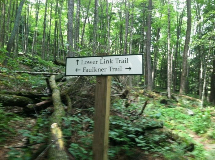
THE FULKNER TRAIL
You’ll Never Stop Exploring Along This One Easy Trail In Vermont by Kristin Grimes OnlyInYourState
The town of Woodstock is well known for it’s unique shops, fabulous restaurants and charming architecture. We’ve written articles like this one which describes the many things to do and see on your trip to this quintessential town, but one thing that should absolutely be on your list is a hike on Mt. Tom. The Fulkner Trail in VT is an easy hike that gives you some great exercise and brings you to to a view from above that will show you Woodstock like never before. Let’s take a look at what you’ll see along the way and be sure to take note of the directions at the end as the trailhead can be tricky to find!
Finding the Faulkner Trail might be the trickiest part of this hike. To get to the trailhead from the center green of Woodstock, find the covered bridge and drive across it. At the first intersection go straight on the Mountain Road which hooks to the left. Travel about 1/8 mile and there is a park on the right and you can park on the street. Follow the black top paths to the rear and you’ll see the path ascending the hillside. Once you find the trailhead, the path is well marked.
Enjoy your trip to the Faulkner Trail in VT during your visit to the charming and quintessential town of Woodstock!
COOLIDGE STATE FOREST
VERMONT STATE PARKS
DEER LEAP~KILLINGTON
Find the trailhead for Deer Leap Overlook at 139 US-4, Killington, VT 05751. For a trail map and directions, copy this: https://www.hikingproject.com/trail/7032203/deer-leap-overlook https://www.trailfinder.info/trails/trail/deer-leap

Posted in Vermont April 09, 2019 by Natalie Clunan of OnlyInYourState
The Magnificent Overlook In Vermont That’s Worthy Of A Little Adventure
Vermont is world famous for its breathtaking mountaintop views. Some are easier to get to than others. But if you aren’t afraid of a little extra effort (and if you’re a Vermont native, we know you’re not), the hike to Deer Leap Overlook will take you to new heights. The sheer beauty visible from this boulder perch is worthy of a little adventure.


